In any drone LiDAR project, precision and accuracy are key to successful outcomes. GeoCue has created a tool that makes this process easier and more reliable—our Concentric Target. It’s designed to streamline your post-processing workflow, ensuring dependable, measurable results. Read more and check out the video below to see how easy and effective the Concentric Target is in action.
The Geomatics Fanatic
A blog dedicated to geomatics by Rick Duchscher
8.07.2025
7.13.2023
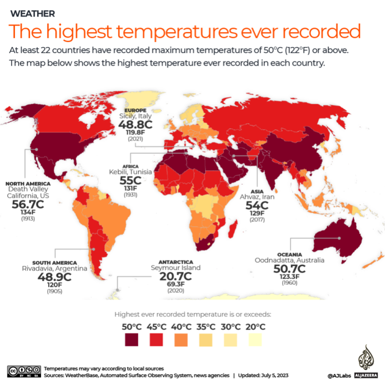
Mapping the Hottest Temperatures around the World
Mapping the hottest temperatures arund the world. To ensure accurate readings, weather stations use specialist platinum resistance thermometers placed in shaded instruments known as a Stevenson screen at a height of 1.25-2 metres (4-6 feet) above the ground. Earth’s global average surface temperature in 2020 tied with 2016 as the warmest year on record. Collectively, the past eight years have been the warmest since modern record-keeping began in the 1880s, according to NASA. Read more...
3.07.2023
Clean Up Australia: Aerologix Drone Pilots Find Hidden Trash
Sydney-based drone startup Aerologix has announced a partnership with Clean Up Australia to assist communities in cleaning hidden pockets of garbage in waterways and nature reserves. This weekend’s cleanup will see pilots focus on capturing aerial footage along the Northern Beaches coastline. The gathered image and video will be used to geolocate trash and highlight hotspots on a map for clean up groups to focus their attention on. Read more...
11.02.2022
Passenger eVTOL in NYC: LIFT Partners with Charm Aviation for Personal Flight Services
Passenger eVTOL in NYC by 2023? LIFT Aircraft Enters Agreement with Charm Aviation for HEXA Aircraft Tours in NYC. Electric vertical takeoff and landing (eVTOL) aircraft developer LIFT Aircraft has announced that it has signed a Letter of Intent (LOI) with helicopter tour agency Charm Aviation to bring a new personal flight service with passenger eVTOL to New York City as early as 2023. Read more...
6.02.2022
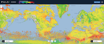
Worldwide Interactive Methane Emissions Map
GHGSat’s global methane monitoring map of the world looks like angry blotches of red paint sprayed on the canvas. Read more...
1.18.2022
Calgary Revamps City Historic Site Mapping Tools
The City of Calgary and Heritage Calgary have launched a revised map with tools to access more than 800 historic sites.The map of evaluated historic sites combined the Discover Historic Calgary map and the Heritage inventory into one map tool. Read more...
10.20.2021
Tethered Drones for Security: Elistair Orion 2 Flies Over Guns N’ Roses Concert
Police responsible for safety at a Guns N’ Roses concert that drew 14,000 fans used Elistair Orion 2 tethered drones for security – here’s why customers including the French defense agency and CNN Air are using tethered drones to secure large events. Read more...
1.04.2021
Canada’s New Drone Can Better Surveil Its Challenging Arctic Environment
After years of experimentation and analysis, the government of Canada has procured a new Hermes 900 StarLiner from Israeli UAV manufacturer Elbit Systems that can withstand and patrol its massive, inhospitable Arctic territory. Read more...
9.08.2020
Orthophoto Survey Drones Help Predict Flash Flooding

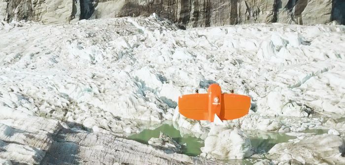
Climate researchers in Alaska are using drones to help track ice and water levels in the Suicide Basin glacial lake. The team, led by Gabriel Wolken, research professor at the University of Alaska Fairbanks Climate Adaptation Science Center, is working to visualize and predict seasonal flux at the glacial lake. It looks at how water interacts with the Mendenhall Glacier, which was once connected to Suicide Glacier before rising temperatures separated them. When basin waters rise to a point, Mendenhall Glacier can no longer hold them and the entire basin drains, causing flash floods. The team is using orthophoto and digital elevation models from a WingtraOne drone to assess changes to water and ice levels at Suicide Basin. Read more...
Apple's New iPad Pro with Lidar Scanner

Apple has announced its most advanced iPad Pro ever, which even includes a Lidar scanner. Equipped with the A12Z Bionic chip, the new iPad Pro is faster and more powerful than many PC laptops. The breakthrough Lidar scanner delivers depth-sensing capabilities, opening up more specialized workflows and supporting professional photo and video apps in combination with the ultrawide camera and studio-quality microphones. Read more...
4.29.2020
Canada’s National Elevation Data Strategy Updates from NRCan

Natural Resources Canada (NRCan) is proud to announce a new release of the product High Resolution Digital Elevation Model (HRDEM). This new and highly accurate data covers approximately 50,000 km2 of new territory and includes areas in Ontario, Manitoba, Nova Scotia, New Brunswick, Quebec, Saskatchewan and British Columbia. Read more...
2.22.2020
Reality Series Features Real Surveyors!
Reality TV-like series “Down to Earth” features surveyors of Rogers-based engineering company Crafton Tull in the first three episodes, titled “The Ozarks.” Read more...
8.20.2019
Lidar Technology for Game of Thrones
Led by Vektra of Croatia, a visual effects team used Teledyne’s lidar (light detection and ranging) technology to create a detailed 3D representation of the old city of Dubrovnik; the model for the fictional city of King’s Landing. They generated 3D point clouds in the set using various lidar technologies, including Teledyne Optech’s Maverick mobile lidar system and Polaris fixed terrestrial scanner. The lidar point clouds were then colourised with digital camera imagery and image fusion software.Read more....
6.03.2019
Fake News: Mars Edition, Circa 1877

When Italian astronomer Giovanni Schiaparelli peered at Mars through a powerful telescope in the late 1800s, he observed dark channels raked across its surface. These features became the key characteristics in his detailed maps of the planet, which fueled more than a decade of wild speculation regarding alien-built canals. Read more...
3.07.2019
Automatically Extracted Buildings Data

Natural Resources Canada recently added a new data layer to the Federal Government Open Data portal to help with emergency management (particularly for flood and earthquake risk analysis).
The data layer consists of delineated building footprints with height and elevations automatically extracted from airborne LiDAR data, high-resolution optical imagery or other sources.Automatically Extracted Building Footprints Open Data for Eastern Canada
The data set available in vector format contains close to 1 million building footprints in several different geographies across the county.
https://open.canada.ca/data/en/dataset/7a5cda52-c7df-427f-9ced-26f19a8a64d6
10.24.2018
Mapping The Hidden Geography Of Language Through The News
Geography gives us an incredible lens through which to see the world. While we often think of maps in terms of information that already exists in the spatial domain, such as building addresses or GPS coordinates, the written word contains a tremendous volume of locative insights. What happens when we combine fulltext geocoding with the power of the cloud to analyze hundreds of billions of words of global news coverage to map the hidden geography of the language of news? Read more...
9.03.2018
The Drone that Submerges, Floats and Flies
After two years of designing and prototyping, the team at SwellProUSA and Urban Drones, a drone technology company, have introduced The Spry - the first ever waterproof drone that can briefly submerge like a submarine, float like a boat, and fly in the air at over 43mph. The Spry has a self-contained 4K camera that can capture video at 30fps, images at 12 megapixels, and wirelessly transmit the video signal to a monitor embedded in its waterproof remote control. Read more...
6.06.2018
MIT Researchers Develop Virtual-Reality Testing Ground for Drones
Training drones to fly fast, around even the simplest obstacles, is a crash-prone exercise that can have engineers repairing or replacing vehicles with frustrating regularity.
Now MIT engineers have developed a new virtual-reality training system for drones that enables a vehicle to "see" a rich, virtual environment while flying in an empty physical space. Read more...
5.03.2018
Perhaps Nobody Knows it Yet, But Geomatics is Cool
The geospatial industry faces a major challenge: how to attract a new generation of mapping and surveying professionals. The sector is crying out for talented young individuals who are willing and able to enter the profession. But, as a quick glance at the labour market reveals, they are currently in short supply, so other measures are needed. A good starting point is to increase the industry’s interaction with children in primary and secondary schools to help them see the relevance of geomatics. Read more...
1.09.2018
FAA Releases Study on Potential Mid-air Drone Collisions
On November 28th the FAA announced the release of a report by the Alliance for System Safety of UAS through Research, aka ASSURE. This report was commissioned in 2015 to test the potential damage to manned aircraft due to mid-air collisions with drones and how that compared to the more traditional airborne hazard: bird strike. The report concludes that drones which collide with manned aircraft can cause more structural damage than birds of the same weight for a given impact speed. Click HERE for more...
9.20.2017
Mapping Noise Pollution with Smartphones
Novel applications include the use of smart phones, such as the NoiseTube application, that measure the location and strength of given noise pollution. By having these sensors deployed via mobile phones, mapping noise pollution can be at a higher density and, consequently, be more accurate over a wider spatial extent. Read more...
2.10.2017
National Energy Board's Oil Spill Interactive Map
Canada's pipeline regulator took a "big step forward" on a promise to be more transparent with the release of a map of spills and other incidents. But gaps in the data still exist.Click here for more...
12.08.2016
Pipelines and Jobs
Do pipelines create thousands of new jobs as claimed by energy companies and governments? Here's some interesting statistics on how many jobs might really be created - both short and long term:
http://www.politifact.com/truth-o-meter/article/2015/jan/09/3-key-keystone-xl-questions-answered/
Mapping the Impacts of Climate Change
Check out this link which displays and ranks how climate change impacts countries in order of urgency. David Wheeler complied data in various categories including sea level rise, extreme weather, agricultural land, etc and performed and ordinal ranking of 233 countries based on vulnerability from the various categories. Click Here to see the interactive map!
8.29.2016
Seeing Through Wildfire Smoke in Fort McMurray, Alberta with Infrared Imaging
Images of the massive wildfire that engulfed Fort McMurray, Alberta earlier this year have been seared into our collective consciousness. Record-setting heat, low humidity, dry conditions and high winds combined to create a destructive “perfect storm” of fire weather the likes of which have been rarely seen anywhere in Canada – much less in an Alberta springtime.Read more...
Subscribe to:
Comments (Atom)


